


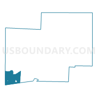
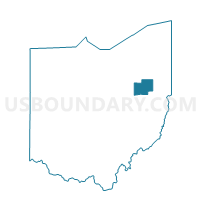
SUGARCREEK TWP 1 Voting District, Stark County, Ohio
About
Outline

Summary
| Unique Area Identifier | 651902 |
| Name | SUGARCREEK TWP 1 Voting District |
| County | Stark County |
| State | Ohio |
| Area (square miles) | 19.72 |
| Land Area (square miles) | 19.72 |
| Water Area (square miles) | 0.00 |
| % of Land Area | 100.00 |
| % of Water Area | 0.00 |
| Latitude of the Internal Point | 40.67000380 |
| Longtitude of the Internal Point | -81.60446610 |
Maps

Graphs
Select a template below for downloading or customizing gragh for SUGARCREEK TWP 1 Voting District, Stark County, Ohio


Neighbors
Neighoring Voting District (by Name) Neighboring Voting District on the Map
- BETHLEHEM TWP 2 Voting District, Stark County, OH
- Voting District PAINT TWP 1 MT EATON, Wayne County, OH
- PRECINCT FRANKLIN TWP, Tuscarawas County, OH
- PRECINCT PAINT TOWNSHIP, Holmes County, OH
- PRECINCT WAYNE TOWNSHIP, Tuscarawas County, OH
- SUGARCREEK TWP 2 Voting District, Stark County, OH
- SUGARCREEK TWP A Voting District, Stark County, OH
- SUGARCREEK TWP C Voting District, Stark County, OH
- SUGARCREEK TWP D Voting District, Stark County, OH
Top 10 Neighboring County Subdivision (by Population) Neighboring County Subdivision on the Map
- Sugar Creek township, Stark County, OH (6,546)
- Bethlehem township, Stark County, OH (5,347)
- Franklin township, Tuscarawas County, OH (4,698)
- Paint township, Holmes County, OH (4,134)
- Paint township, Wayne County, OH (3,209)
- Wayne township, Tuscarawas County, OH (2,164)
Top 10 Neighboring Place (by Population) Neighboring Place on the Map
Top 10 Neighboring Unified School District (by Population) Neighboring Unified School District on the Map
- East Holmes Local School District, OH (20,863)
- Southeast Local School District, OH (17,897)
- Fairless Local School District, OH (12,083)
- Garaway Local School District, OH (10,839)
- Strasburg-Franklin Local School District, OH (4,551)
Top 10 Neighboring State Legislative District Lower Chamber (by Population) Neighboring State Legislative District Lower Chamber on the Map
- State House District 97, OH (124,815)
- State House District 96, OH (124,049)
- State House District 50, OH (114,718)
- State House District 3, OH (114,520)
Top 10 Neighboring State Legislative District Upper Chamber (by Population) Neighboring State Legislative District Upper Chamber on the Map
- State Senate District 22, OH (370,237)
- State Senate District 30, OH (338,710)
- State Senate District 29, OH (337,506)
Top 10 Neighboring 111th Congressional District (by Population) Neighboring 111th Congressional District on the Map
Top 10 Neighboring Census Tract (by Population) Neighboring Census Tract on the Map
- Census Tract 17, Wayne County, OH (7,518)
- Census Tract 7148.01, Stark County, OH (6,546)
- Census Tract 9763.02, Holmes County, OH (5,687)
- Census Tract 201, Tuscarawas County, OH (4,922)
- Census Tract 7148.02, Stark County, OH (2,834)
Top 10 Neighboring 5-Digit ZIP Code Tabulation Area (by Population) Neighboring 5-Digit ZIP Code Tabulation Area on the Map
- 44662, OH (9,656)
- 44624, OH (5,397)
- 44680, OH (4,138)
- 44608, OH (2,666)
- 44613, OH (2,011)
- 44689, OH (638)